- +1 281.389.0771
- info@olgess.com
-
Mon - Fri: 8:00 - 17:00 / Closed on Weekends
INDUSTRY ANALYSIS
The Eaglebine play is located on the northeastern trend of the Eagle Ford
where the Eagle Ford Shale meets the Woodbine Sandstone. The Eaglebine and
Eagle Ford share similar geology, as they are both situated above the Buda
Formation and below the Austin Chalk. However, the Eagle Ford is a carbonate-rich organic, while the Eaglebine contains a large percentage of silica-rich
sands interlaced in the organic-rich shale. This makes the Eaglebine
formation complex to exploit with many layers of source rock, high
hydrocarbon potential, but like the Eagle Ford a mixture of oil and
condensate liquids. The Eaglebine formation can exceed 1,000 feet in
thickness and is found at depths between 6,500 and 15,000 feet. The map
below shows the approximate location of the Eaglebine (red shaded area)
relative to the eastern part of the Eagle Ford (blue shaded area) and the
southern tip of the Woodbine (green shaded area). The main counties where
drilling has occurred in the Eaglebine are Leon, Madison, Brazos, Grimes,
Walker and Polk.
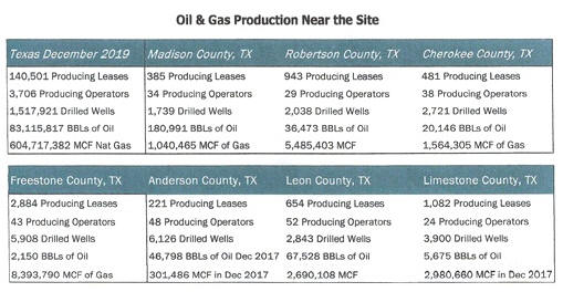
Substantial Oil & Gas operations have been conducted in and around the
F.U.S.I. site for almost 100 years. Through various business cycles, the
number of existing wells, gathering systems, and product pipelines has
proliferated, providing an almost continuous engine for growth. As such, the
F.U.S.I. site can depend upon small regional E & P players, larger, heavily
funded nationwide players, and a coterie of oilfield waste and fluids
transportation providers.
REVENUE DRIVER: EXISTING WELLS IN THE IMMEDIATE AREA
The Woodbine Sand is the productive reservoir for the huge 6 billion Bbl.
East Texas oil field first exploited in the 1930's that was the largest
oilfield in the world in its time. The Woodbine has largely been exploited
using conventional vertical drilling technology but in recent years a number
of companies have successfully applied horizontal drilling and hydraulic
fracturing technology in the Southeast Texas part of the formation.

